
The UK will wake up to a freezing morning and heavy snow as the cold spell tightens its grip.
Three weather warnings for snow are in place for Wednesday, with the South East, the North East and Scotland set to be most affected.
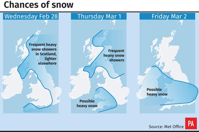
Heavy snow showers are expected overnight up until around 10am hitting the East, South East and East Midlands, the Met Office said, issuing an amber warning.
An amber severe weather warning for #snow has been issued: https://t.co/QwDLMfRBfs. Stay #weatheraware @metofficeuk pic.twitter.com/5oWNkGJLav
— Met Office (@metoffice) February 27, 2018
This will bring up to 15cm of snow, which is likely to cause vehicles to become stranded and cause delays to road, rail and air travel, the Met Office said.
A separate amber weather warning for snow is in place for parts of Scotland and the North East between 6am on Wednesday and 6pm on Thursday, which will bring up to 40cm of snow in some areas.
And a yellow warning covers most of the rest of England and northern Ireland all day and into the evening, with up to 10-15cm expected.
Forecasters warned that long delays on bus, rail and air travel, plus disruption to phone networks, could occur.
A number of warnings are in force across the country over the next few days, including a couple of amber 'be prepared' warnings for heavy snow – stay #weatheraware pic.twitter.com/knJa7ZQ5yM
— Met Office (@metoffice) February 27, 2018
Strong winds will lead to drifting of snow and severe wind chill, the Met Office said.
Highways England, which said it had received reports of numerous stranded lorries on Tuesday evening, said drivers should reduce their speed and pack a snow kit of blankets, food, water and a shovel.
Four people died in car crashes amid the heavy snow on Tuesday.
The bitter conditions forced Northumbria Police to declare a major incident and set up a temporary reception centre after a fire in Newcastle left 500 homes without power.
A major incident has been declared after more than 500 homes were left without power in Cowgate. A big thanks to @Morrisons for staying open as a reception centre with hot drinks and food for those affected. The @BritishRedCross are also there. More here: https://t.co/kblbE2BWOQ pic.twitter.com/4IrbQO7Xn4
— Northumbria Police (@northumbriapol) February 27, 2018
The force tweeted shortly after 1am on Wednesday that electricity had been restored to all homes.
The Met Office said overnight into Wednesday would be “exceptionally cold”, with the potential for the mercury to dip as low as -10C in parts of Scotland.
Dozens of schools in Scotland will remain closed on Wednesday, including all schools in East Renfrewshire, East Dunbartonshire, Fife, Stirling and Fulbrick.
Other areas are expected to announce any closures in the morning.
Rail companies have warned delays may continue into Friday.
Southeastern said it was planning to run a normal service but that some rush-hour services would be altered and it would look to introduce an emergency timetable “if conditions deteriorate significantly”.
We're running our normal timetable tomorrow, but as a precaution, we've lengthened some trains to ensure they are more reliable in snow and ice. To enable this to happen we have, unfortunately had to cancel some trains. Here's details of the known morning rush-hour cancellations pic.twitter.com/HJQWHEm5Ua
— Southeastern (@Se_Railway) February 27, 2018
British Airways said the weather was likely to continue disrupting flights throughout the week.
It will proactively reduce flight schedules at Heathrow Airport “for several hours during the worst of the weather” on Wednesday.
Flights for later on in the week are “under regular review”.
Norwich Airport confirmed it had closed on Tuesday evening.
Conditions are not likely to improve for several days, with forecasters warning that snow will continue well into the week.
Forecaster Frank Saunders said parts of the country could see their “coldest spell of weather since at least 2013, and possibly since 1991”.
It is expected that the mercury could plummet to minus 15C by midweek where there is snow on the ground, rivalling temperatures forecast for parts of northern Norway and Iceland.
From Thursday, forecasters predict that another weather system, Storm Emma, will bring blizzards, gales and sleet as it meets the chilly “Beast from the East” later this week.
The storm, named by the Portuguese Met Service, will move north through Europe and is due to hit the UK on Thursday and Friday, and will be “significantly disruptive”, bringing the risk of power cuts and transport delays.


Comments: Our rules
We want our comments to be a lively and valuable part of our community - a place where readers can debate and engage with the most important local issues. The ability to comment on our stories is a privilege, not a right, however, and that privilege may be withdrawn if it is abused or misused.
Please report any comments that break our rules.
Read the rules here